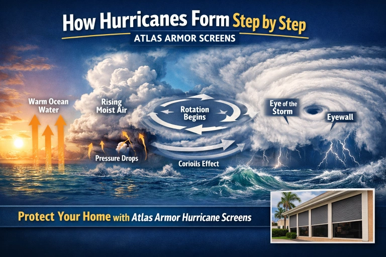
Hurricanes are not random storms that appear out of nowhere. They are powerful weather systems that form through a precise sequence of atmospheric and oceanic events. Each step builds on the last, and when all the conditions align, a simple cluster of storms can evolve into a massive, organized system capable of causing widespread damage.
Understanding how hurricanes form helps explain why storms can intensify quickly, why some systems never fully develop, and why preparation must happen long before landfall. That understanding is also what drives smarter protection choices, such as hurricane fabric roll-down screens, which are engineered to respond to the forces created during each stage of storm development.
Step 1: Warm ocean water provides the energy
Hurricanes begin over warm ocean water. The surface temperature of the water acts as the fuel source. Warm water increases evaporation, sending large amounts of moisture into the air above the ocean. That moisture stores heat energy, which becomes the driving force behind the storm’s growth.
This is why hurricanes form in tropical and subtropical regions and why they weaken when they move over cooler water.
Step 2: Warm, moist air starts rising
As the moist air above warm water heats up, it becomes lighter than the surrounding air and begins to rise. Rising air creates areas of lower pressure near the surface. Nature tries to balance pressure differences, so nearby air flows in to replace the rising air.
This process triggers clusters of thunderstorms, often sparked by a tropical wave or another atmospheric disturbance.
Step 3: Condensation releases heat
As rising air cools, water vapor condenses into cloud droplets and rain. During condensation, heat is released into the surrounding air. This released heat warms the air column, making it rise faster.
This cycle explains why hurricanes are powered by heat and moisture rather than wind alone. It also helps explain why flexible systems like hurricane fabric roll-down protection perform so well as pressure and wind forces increase.
Step 4: Surface pressure drops and air rushes inward
As air continues to rise, surface pressure drops further. Air from surrounding areas flows inward toward the low-pressure center. The stronger the pressure difference, the faster the air moves toward the center of the system.
At this point, the storm begins acting like a single organized system rather than scattered thunderstorms.
Step 5: Earth’s rotation creates spin
As air flows inward, Earth’s rotation causes it to curve. This deflection, known as the Coriolis effect, gives the storm its rotation. In the Northern Hemisphere, hurricanes rotate counterclockwise.
This is also why hurricanes do not form directly at the equator, where the Coriolis effect is too weak to organize rotation.
Step 6: A tropical depression forms
Once a closed circulation develops near the surface, the system becomes a tropical depression. Winds remain relatively low, but the structure is improving. Thunderstorms cluster closer to the center, and curved rainbands may begin to appear.
Many storms never progress past this stage because dry air, cooler water, or disruptive upper-level winds break the cycle.
Step 7: Strengthening into a tropical storm
If conditions remain favorable, winds increase and pressure continues to fall. When sustained winds reach tropical storm strength, the system is officially named.
At this stage, damage risk increases for exposed openings. This is where hurricane fabric roll-down screens become especially important, as they are designed to absorb energy, resist debris impact, and manage pressure changes as the storm strengthens.
Step 8: A warm core develops
Unlike other storm systems, hurricanes develop a warm core. The center of the storm becomes warmer than the surrounding atmosphere at the same height. This temperature difference lowers surface pressure even further, accelerating wind speeds.
This is why hurricanes can intensify rapidly when conditions are ideal and why protection must be installed well before a storm approaches.
Step 9: Eye and eyewall formation
As the storm strengthens, winds concentrate into a ring of intense thunderstorms known as the eyewall. Inside this ring, the eye forms, often calmer and clearer than the surrounding areas.
The eyewall contains the strongest winds and heaviest rain, along with the most dangerous debris impacts.
Step 10: A fully developed hurricane
Once sustained winds reach hurricane strength, the system is classified as a hurricane. Its future intensity depends on its environment. Warm water, moist air, and stable atmospheric conditions allow strengthening. Cooler water, land interaction, dry air, or wind shear cause weakening.
Hurricanes lose strength gradually, not instantly. That prolonged exposure is why long-duration protection systems are critical.
Why understanding hurricane formation matters
Knowing how hurricanes form explains why some storms intensify suddenly, why damage patterns vary, and why preparation must happen early. Hurricanes are powered by heat and moisture, then organized by physics. When that energy is efficiently organized, the impact on buildings can be severe.
What Makes Atlas Armor Screens Different
Atlas Armor builds more than just screens — they build confidence. Every system is made from DuPont™ Kevlar®, a UV-protected material known for its strength and flexibility. The design is engineered to stay steady in extreme winds, while its tight weave stops debris and resists air pressure that could otherwise damage your home.
Their versatility makes them ideal for patios, lanais, doors, and wide openings, giving full coverage without blocking your view. These aren’t decorative mesh panels — they’re tested and certified protection built to perform when conditions turn dangerous.
Atlas Armor’s screens are even rated to defend against EF0, EF1, and EF2 tornadoes (65–135 mph winds), which often accompany hurricanes and tropical storms. Few products on the market can match that level of durability.
Fast delivery, no waiting: orders ship to your local dealer in about four to six weeks, often sooner. Whether you’re protecting a single-family home or a large commercial property, you won’t wait months for coverage.
Why homeowners choose Atlas Armor:
- Over 11 years of storm protection experience
• Zero product failures in 55 major windstorms
• The only company offering a wind-only damage warranty
• Certified by Miami-Dade County and Texas Department of Insurance (TDI)
• Fast dealer delivery within 4–6 weeks
That’s not marketing talk — it’s a track record proven through real storms and verified testing.
What Makes Hurricane Screens Better Than Shutters
Traditional shutters block your view and leave your home dark for days. Hurricane Screens are transparent, flexible, and lightweight. They protect your home while allowing natural light and visibility. You can deploy them quickly, stay protected, and still see what’s happening outside as the storm passes.
Preparing for the Next Name on the List
Whether the forecast mentions Hurricane Milton or Hurricane Nadine, the approach remains the same: stay informed, secure your home, and act early. Preventing damage is far more effective and affordable than repairing it after failure occurs.
Modern hurricane protection depends on understanding storm behavior and using materials engineered for real-world conditions. Atlas Armor designs hurricane fabric roll-down systems to stand up to extreme winds, pressure shifts, and debris impact, giving homeowners one less thing to worry about when conditions turn dangerous.


